File:Ethiopian Civil War (2020-present).svg

.svg)
| 该文件可能会更新以反映新信息 如果您希望在不镜像新更新的情况下使用该文件的特定版本,请将所需版本作为单独的文件上传。 |
摘要
| 描述 |
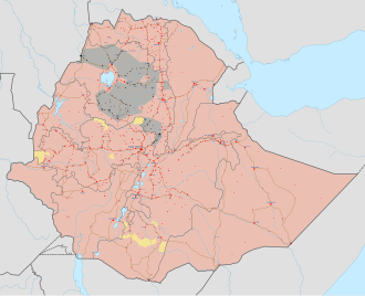
English: Map of the Ethiopian Civil War (2020-present). All credit goes to Ethiopia Map's (https://twitter.com/MapEthiopia)
Information to readers: Click on the image to make marks and icons visible, which are otherwise too small. To zoom into the image after you opened it, hold ctrl and scroll in/out with your mouse. To view the image in full quality, open it in Media Viewer, download the original file and open it with Inkscape (free drawing program). Information to editors: This file is completely based on the Template:Ethiopian wars and insurgencies detailed map. If you want to change something here, you first need to make a properly sourced edit at the Templates' Module. The program you need to the map (and any other Scalable Vector Graphics-file (SVG)) is called Inkscape, which is a free accessible program. To be able to add marks and icons at the correct place, I recommend you to make a screenshot (alt gr + print). This screenshot you insert temporarily at the file, put it in the right size under the marks and then look at the streets and the borders, if it's at the right place. If you did this, you only need to look, where the Template shows a mark which isn't already at the map. Good luck and thanks for helping to improve the map!
|
| 日期 | |
| 来源 | 自己的作品, derived from the Template:Ethiopian wars and insurgencies detailed map and File:Ethiopia adm location map.svg by NordNordWest |
| 作者 | Rr016 |
许可协议
- 您可以自由地:
- 共享 – 复制、发行并传播本作品
- 修改 – 改编作品
- 惟须遵守下列条件:
- 署名 – 您必须对作品进行署名,提供授权条款的链接,并说明是否对原始内容进行了更改。您可以用任何合理的方式来署名,但不得以任何方式表明许可人认可您或您的使用。
- 相同方式共享 – 如果您再混合、转换或者基于本作品进行创作,您必须以与原先许可协议相同或相兼容的许可协议分发您贡献的作品。
文件历史
点击某个日期/时间查看对应时刻的文件。
| 日期/时间 | 缩略图 | 大小 | 用户 | 备注 | |
|---|---|---|---|---|---|
| 当前 | 2025年11月23日 (日) 15:15 | | 1,843 × 1,494(2.74 MB) | wikimediacommons>BorysMapping | Updated Amhara using: https://reliefweb.int/map/ethiopia/ethiopia-national-access-map-31-october-2025, https://www.criticalthreats.org/wp-content/uploads/20251002-Ethiopia-AF-Fano-Battlemap.png |
文件用途
以下页面使用本文件:
.svg)